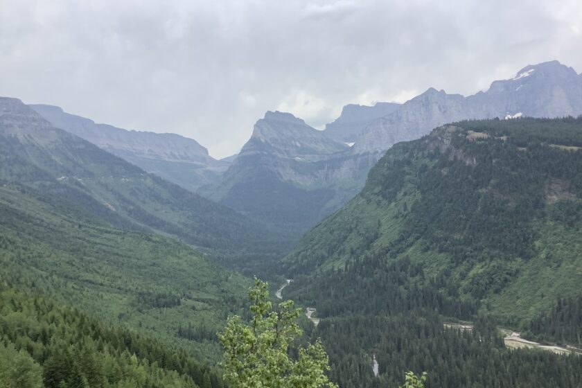
Glacier National Park, Montana. At St. Mary’s on the east side of Glacier National Park we started up the Going-to-the-Sun-Road, that winds for fifty miles through steep, rugged terrain and ends on the west side of the park at West Glacier. There are ten mountain peaks over 10,000 feet, waterfalls that cascade down the sides of the rocky terrain, thick green pine forests and overlooks from where we could see across to mountains with intermittent glacier fields. Seven thousand years ago, the glaciers carved out the giant smooth round hollows between the mountains.
To the Blackfeet tribe these rugged mountains, are known as the Backbone of the World that they climb during their religious vision quests, especially Chief Mountain and the area southeast of Two Medicine. Just east of the park, the terrain drops abruptly to semi-arid flat lands where the Blackfeet reservation is centered in the town of Browning, Montana. We stopped in a supermarket in Browning and were impressed by the store employees and customers who were almost all Blackfeet. The men and women alike are an exceedingly tall and handsome people, with round, pleasant faces, distinguished by prominent cheek bones and glowing reddish-brown complexions.
The reservation today covers 3,000 square miles, twice the size of Glacier National Park and home to more than 15,000 Blackfeet. In 1895 the Blackfeet were pressured into ceding their mountain lands of Glacier to the federal government. Yet, they seem to have survived their tragic history with the white man with their enduring spirit still intact.
Glacier National Park in northwest Montana is part of the high mountain ecosystem that extends north across the Canada-U.S. border to join Alberta’s Waterton Lakes National Park. The two parks were designated in 1932 as the Waterton-Glacier International Peace Park to commemorate the bonds of friendship between the two nations. In 1995 it was named a World Heritage Site that contained not only a unique natural area of North America but also the cultural heritage of the Blackfeet, Flathead, Salish, Kootenai and Pend d’ Oreille tribes.
The two parks are part of the Crown of the Continent Ecosystem that straddles the Continental Divide. It is where the Triple Divide Peak, the hydrological apex of the North American continent, feeds three of the continent’s major river systems, the Columbia, the Missouri and Saskatchewan. The Columbia River flows northwest in Alberta, Canada, then turns south into Washington State. From there it flows west and forms the border between Oregon and Washington and finally empties after a 1,243-mile trek into the Pacific at Astoria, Oregon. The Columbia River’s vast drainage basins cover seven U.S. states and two Canadian provinces.
The Missouri River, the longest river in North America, also flows from Triple Divide Peak and flows to the east and south for 2,341 miles before entering the Mississippi River at St. Louis. It eventually empties into the Gulf of Mexico near New Orleans. Its water shed covers eleven U.S. states that comprise one quarter of the agricultural land in the U.S. The Missouri’s largest watershed cities are Denver, Omaha and Kansas City.
Rainfall on the north slope of the Triple Divide Peak flows down to forms creeks and rivers including the Saskatchewan River system that eventually empties into Hudson Bay in northeastern Canada.
At the end of the Little Ice Age, the Mid 19th Century, there were 146 glaciers in Glacier National Park. Today, the U.S. Geological Survey, counts just 26 that are considered true glaciers, more than 25 acres in size and of sufficient mass to move under their own weight.
The park has seen a 68% loss of glacier surface area since 1850. All remaining glaciers in the park are expected to disappear by 2030 if there is no immediate and sharp reduction of carbon from human activities that create the greenhouse effect and global warming.
As global atmospheric temperatures have risen an average of 1.8 F since the Industrial Revolution, there is less snowfall to form ice packs. Spring ice melts two weeks earlier and rain replaces early snow. Glaciers can only add size when during the winter months, more snow is added to the ice sheet than is lost in the summer melt.
In Montana and much of Canada, temperatures are rising twice as fast as global averages. And in northern Canada, temperatures are rising three times faster.
As the U.S. Geological Survey stated, ‘In Glacier National Park some effects of climate change are strikingly clear, glaciers are melting, and many glaciers have already disappeared. The rapid retreat of these small alpine glaciers reflects changes in recent climate and precipitation.’
In the park, plant and animal species rely on spring melting of glaciers for cool forest habitat and cold water in streams during late summer. It is essential to the health of native fish such as cutthroat trout and aquatic insects that are at the base of the aquatic food chain.
From Glacier National Park to the Himalayas to the Swiss Alps, glaciers cover 10% of the Earth’s surface, including Antarctica and Greenland. Glaciers store 75% of the world’s fresh water. If all the world’s glaciers melted, seal levels would rise an astonishing 265 feet. If only mountain glaciers melted, without Antarctica and Greenland, sea levels would rise 20 feet.
According to the Intergovernmental Climate Change (IPCC) 2013 report, under a moderate projected atmospheric temperature increase of only 3.6 F degrees by 2100, 66 % of worldwide glacier volume will be lost. If we continue to increase greenhouse gases, at the present rate of 2 degrees a year, atmospheric temperatures will increase by 8.5 F degrees by 2100 and 95% of the world’s glacier ice will be lost.
The Himalayas are 1,500 miles wide and span Nepal, India, Pakistan, Afghanistan, Bhutan and China. They are the location of the largest snow and ice deposits in the world. The Himalayas have 1/3 of the world’s non polar ice and are referred to as the third pole. The Himalayas are the source of water for the largest river systems in Asia, the Ganga-Brahmaputra, Indus and Yangtze and they supply drinking water and irrigation to one sixth of the world’s population.
A June 2019 study in Science Advances, based on U.S. spy satellite images, showed that the largest 650 Himalayan glaciers melted at twice the rate during the period from 2000 to 2016 compared to the period 1973 to 1980. Water supplies to hundreds of millions of people in Asia are at risk.
The Snows of Kilimanjaro, the namesake of Hemingway’s novel in Tanzania, formed the largest glaciers in Africa. At 19,341 feet, the peaks are the tallest on the continent. The base of the ice field dates from the Holocene, 11,700 years ago. From 1913 to 2016, the ice sheets have shrunk from 11.40 square kilometers to only 1.76 square kilometers.
Globally, glaciers lose three times the amount of ice contained in Europe’s Alps each year, 335 billion tons. From 1961 to 2016 the planet has lost 9 trillion tons of ice.
Around each sharp turn of the Going-to-the-Sun road in Glacier National Park we spent hours gazing in awe at spectacular jutting peaks and the beautiful white, glacier fields that were interspersed only here and there between the mountains. We stopped at Logan Pass, the highest point on the road that is located along the Continental Divide. Mountain goats grazed on the slopes.
When we finally reached the west side and drove out of the park, a silent melancholy overcame us.
Al Gore suggested that Glacier National Park should be renamed as ‘The Park Formerly Known as Glacier’.